New proposed bus and cycle routes
 After discussions in the Cycling Liaison Group Meeting held in January, early working drafts of the borough’s future cycle and bus route maps have been created so that residents and road users can feedback their comments.
Due to ever-increasing travel prices, healthier lifestyle choices and government programmes, the number of people using cycles on our roads has increased significantly in recent years. The Council is committed to supporting cyclists that live and travel through our borough through these designated cycle routes and off-road/quiet cycle routes.
Suggestions for amendments and corrections (to the routes and the maps themselves) will be collated and forwarded to “LBRuT Smarter Travel” by Teddington Society’s Roads and Transport group organiser – email brianholder99@aol.com in plenty of time before the Council’s 14th of February so that they can be taken into consideration before the final maps are published in March.
Draft maps:
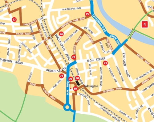
Cycle routes
Bus routes
[Update 5th February 2011] Richmond Cycling campaign secretly launched their ‘Lighten Up’ event by Teddington Lock footbridge on Thursday Night. The aim is to stop cyclists and offer to fit lights for free to raise awareness of the importance of having lights when cycling in the dark.
15 sets of lights were fitted to bikes where existing lights were either broken, of poor quality or simply missing. Other events are planned in the borough this month at further mystery locations and dates. If you like to help out volunteering then contact info@richmondlcc.co.uk.


It does not say what is involved in making a cycle route; are they just signposted?
Hi Peter I believe the main cycle routes are or will be signposted and marked on the roads (or as cycle lanes?), but not sure about the “off-road and quiet cycle routes suitable for family groups”.
Thanks for info; its just that with parking down both sides of the roads there is no room for a separate cycle lane. Also The Causeway leading to a right turn on to Park Road would be dangerous; it could follow the existing cycle way up the Broad Street bridge and then turn right.
Actually what I’ve said is really just an educated guess! Perhaps if you email your concerns to Brian (address above)?
The Map is just that – pointing out how quieter roads can be used to make journeys as well as marking existing cycle lanes. It is to be hoped that more signing on the ground will follow – having ones head in a map does not contribute to road safety.
Is is rather a moot point whether turning right via The Causeway is more hazardous than using the roundabout – it certainly avoids a hill.